
It is roughly 270 years since a government in Westminster had Hadrian’s Wall systematically demolished and crushed to make the road that now brings the tourists to see the bits they missed. It helped create a vast fragmentary jigsaw puzzle that which has proved difficult to piece together.
In 2008, I recognised that my colleagues and others had discovered, under the streets of Tyneside, the remains of a temporary timber rampart predating the stone Wall. This observation explained the strategic methodology of Wall construction, shed light on the motivation, while providing a starting point for the process in both time and space; it was a key piece of the jigsaw; a how, why and where for the start of the Wall.
Since then I have been systematically realigning the existing pieces around this new bit of the puzzle, admittedly, I have had to turn several pieces round and reposition them quite significantly, but they now fit together to produce a picture that makes consistent sense. While previous articles over 7 years a give a more nuanced account of this research, and offer an opportunity to view its development, this account discusses this new understanding in a fairly concise form, particularly those ideas that depart significantly from the consensus. For example, I argue that from an engineering point of view and on the balance of probability that The Vallum was intended as trench for a roadbed for frontier road that was never built. However, I can demonstrate the idea of the ”Turf Wall” – a wall made from turf, is demonstrably false in any objective or empirical sense and inconsistent with the evidence; it was another part of an initial timber rampart.
Although we have only a vague historic framework to which
the archaeology has to be fitted, there is a natural tendency to associate
archaeological event horizons with the rare historical references to Britain in
Roman sources; these associations do tend to produce presumptions which should
really be qualified in terms of what we don’t know. In
addition to the scant literature, many historical details have been
painstakingly pieced together from snippets of information in letters, poems,
together with inscriptions on coins, monuments and graves. As result, while their might even be a general consensus
about some of it, the bits of the puzzle don’t really fit together, and consequently,
tend to present a fundamentally irrational account of the actions of both the
Romans and their opponents in this early period.
 Originally, strategic and political interest in Britain lay in
helping secure Gaul, and by the time of Hadrian it was clear that while southern
England was of economic value, the importance of the north lay in securing the
south.Our best understanding of the strategic situation comes from
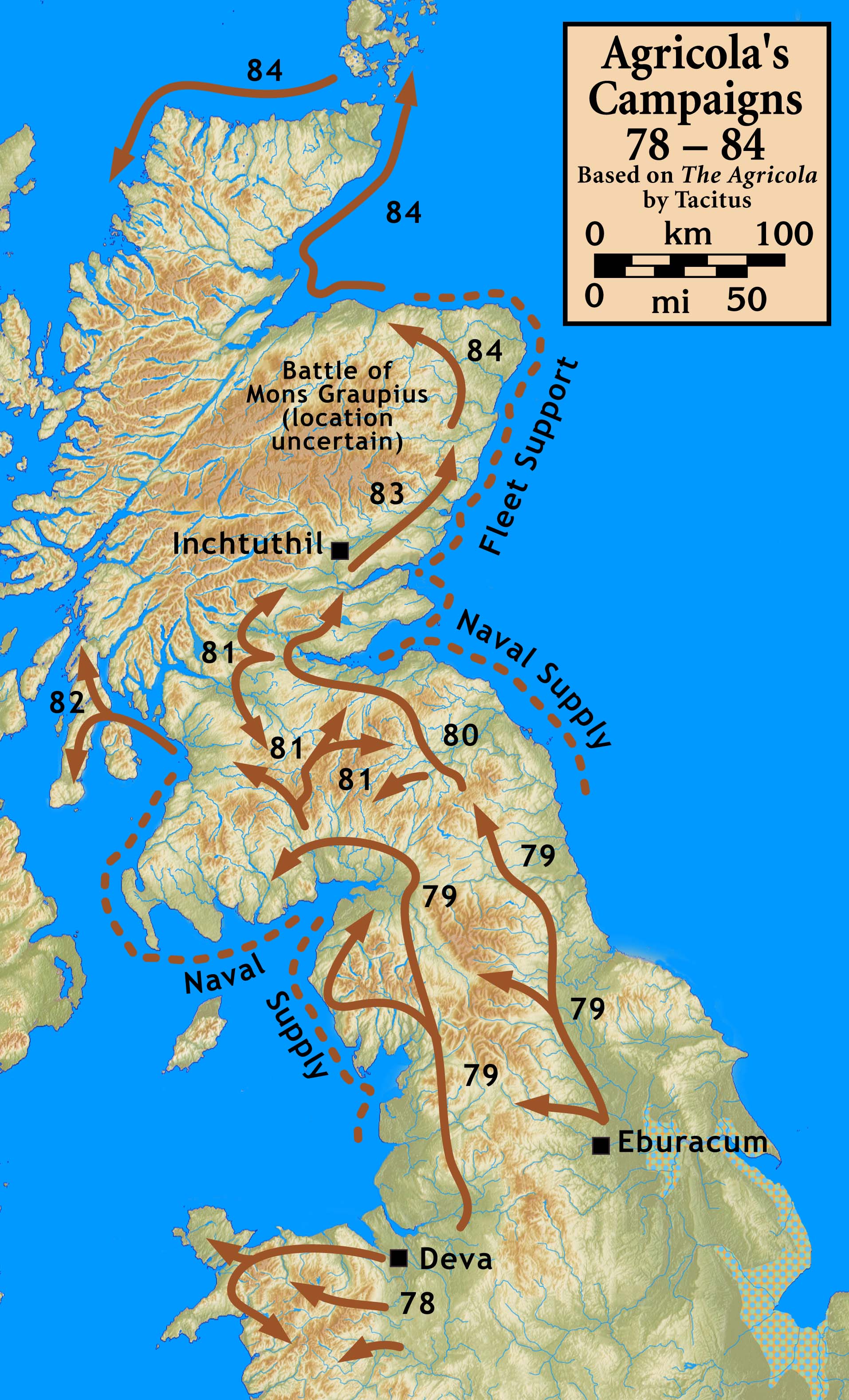
the Roman historian Tacitus, whose father-in-law Agricola, as governor of Britain
had fought a 6 year campaign of conquest of the North of the island, culminating
in the defeat of 30,000 Caledonians at the Battle of Mons Graupius in AD 84. However, this was followed by a strategy of containment, and
later retreat, leaving an over-the-horizon threat in the form of the Highlands
and Islands as well as Ireland, which as Tacitus points out, should or could
have been brought under Roman control when the opportunity has presented itself. The failure to conquer the entire Island ensured that it was never
secure and this section of the Empires frontier continue to tied down three
legions in perpetuity.
Originally, strategic and political interest in Britain lay in
helping secure Gaul, and by the time of Hadrian it was clear that while southern
England was of economic value, the importance of the north lay in securing the
south.Our best understanding of the strategic situation comes from
the Roman historian Tacitus, whose father-in-law Agricola, as governor of Britain
had fought a 6 year campaign of conquest of the North of the island, culminating
in the defeat of 30,000 Caledonians at the Battle of Mons Graupius in AD 84. However, this was followed by a strategy of containment, and
later retreat, leaving an over-the-horizon threat in the form of the Highlands
and Islands as well as Ireland, which as Tacitus points out, should or could
have been brought under Roman control when the opportunity has presented itself. The failure to conquer the entire Island ensured that it was never
secure and this section of the Empires frontier continue to tied down three
legions in perpetuity.
 While Trajan’s reign had been marked by campaigning,
Hadrian’s was marked by consolidation, with the army digging in and even making
strategic withdrawals. In this context the Wall can be seen as merely the western
end of a series of frontier works or Limes, which were mostly completed in
timber. Thus, the initial rampart and ditch is entirely typical of
Roman military works in this period, what is odd is the stone wall, however,
unlike the rest of the Northern frontier, it crosses a relatively narrow
isthmus where there is an ample supply of suitable stone and limestone, so it was
doable; in theory.
While Trajan’s reign had been marked by campaigning,
Hadrian’s was marked by consolidation, with the army digging in and even making
strategic withdrawals. In this context the Wall can be seen as merely the western
end of a series of frontier works or Limes, which were mostly completed in
timber. Thus, the initial rampart and ditch is entirely typical of
Roman military works in this period, what is odd is the stone wall, however,
unlike the rest of the Northern frontier, it crosses a relatively narrow
isthmus where there is an ample supply of suitable stone and limestone, so it was
doable; in theory.
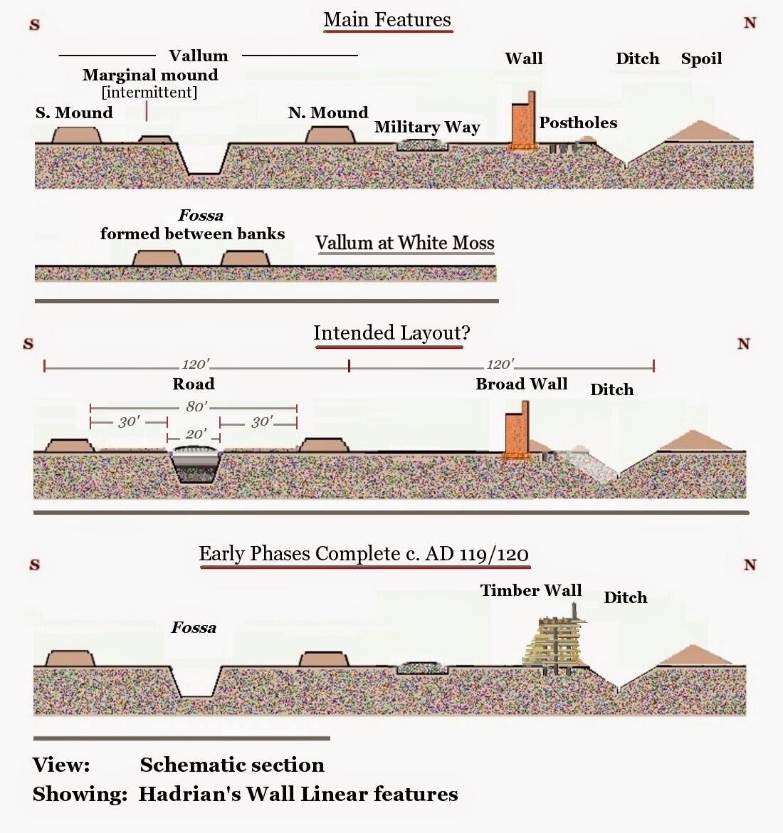
 How was the Wall built?

 “The first labour was to prepare furrows and mark out the borders of the road, and to hollow out the ground with deep excavation ; then to fill up the dug trench with other material,…..''
Firstly, it is not a “ditch”, there is an example dug by the Roman army a few yards away which typical of every other “V” profile ditch; this is a trench with a flat bottom and sides cut as steeply as the soil will bear, which explains why it is famously cut vertically through the bedrock at limestone corner, whereas the nearby Wall Ditch is unfinished.

In marked contrast to The Ditch, the whole earthwork was meticulous laid out, running from the Bridgehead at Newcastle continuously to the end of the Wall at Bowness, it does not always follow the defensive line of the wall, but rather the optimum course for a road. It was to have comprised two soft lanes for pedestrians and riders, with a central metalled carriageway for wheeled vehicles. It runs from with long straight stretches, gentle gradients, and curves to suit the poor turning circles of Roman military wagons.

Road building and quarrying was the original hard labour usually done by criminals and slaves, so apart from supervision, the only task that required skill is the creation of the paved road surface. After the first dislocation, it appears to have been no longer practical to finish building the curtain wall to its original specification, and in this context of manpower shortage, the project seems to have been completely abandoned or shelved leaving only a massive enigmatic cutting through the landscape.
However, the most puzzling aspect of the structure is that at some point it appears all the presumed crossings required to cross the trench, were removed and the spoil piled along the southern edge of the trench forming an intermittent feature known as the marginal mound. Since it seems completely improbable these were removed to facilitate the initial stage of roadbed construction, then the only reasonable context is that the Romans removed the crossings because they were in imminent danger of attack and wished to protect their rear as best they could to mitigate against any breakthrough.
 In AD 132, 10 years after Hadrian’s visit, we know that Julius Severus his best general was governor of Britain, and that he was recalled from here to lead the brutal war against the Bar Kochba rebellion in Judea; he was in many ways typical of military hard men/political trouble-shooters who were trusted with the government of the province. [ left: Statue of Hadrian from Tel Shalem in Israel, probably marking the Roman suppression of the Bar Kochba rebellion at the end of his reign]. It is thought that it was his successor Sisenna who may have been responsible for finally finishing off the Western end of the Wall in the 130's, which given the scale and quality of the achievement in the first couple of seasons around the time of Hadrian’s only visit in 122, is a measure of the reverses that had been suffered. The abandonment of the project to build the frontier road represented by The Vallum, a previously unrecognised aspect of the project, further emphasises the severity of the manpower shortage evident from the decline in both quality and scale of the works following the first dislocation.
While Hadrian’s frontier was reoccupied a generation later, it is clear that that that Wall had not worked, and presumably was considered indefensible with the resources available at the time.
In AD 132, 10 years after Hadrian’s visit, we know that Julius Severus his best general was governor of Britain, and that he was recalled from here to lead the brutal war against the Bar Kochba rebellion in Judea; he was in many ways typical of military hard men/political trouble-shooters who were trusted with the government of the province. [ left: Statue of Hadrian from Tel Shalem in Israel, probably marking the Roman suppression of the Bar Kochba rebellion at the end of his reign]. It is thought that it was his successor Sisenna who may have been responsible for finally finishing off the Western end of the Wall in the 130's, which given the scale and quality of the achievement in the first couple of seasons around the time of Hadrian’s only visit in 122, is a measure of the reverses that had been suffered. The abandonment of the project to build the frontier road represented by The Vallum, a previously unrecognised aspect of the project, further emphasises the severity of the manpower shortage evident from the decline in both quality and scale of the works following the first dislocation.
While Hadrian’s frontier was reoccupied a generation later, it is clear that that that Wall had not worked, and presumably was considered indefensible with the resources available at the time.
How did it all go so wrong?


Sources and further reading
Bidwell, P T, 2005 'The system of obstacles on Hadrian's Wall; their extent, date and purpose', Arbeia J, 8, 53-76.
Johnnie Shannon -Hadrian's Wall and path, section near Crag Lough
In addition, a rather confused general model conditions the
nature of thinking and the specific question archaeologists are trying to
answer in excavation; a more detailed scrutiny of the evidence demonstrates the distressing ability for
archaeologists to find what they are looking for, rather than a understanding
of what was actually there.
Our view of the wall is a concretion of ideas, some dating
back to Venerable Bede, 1300 years ago, and many have been retained long after
they outlived their usefulness due to the reputation of their author.
In recent years the key development in understanding the
archaeology of the Wall developed by David Breeze and others is the idea of “dislocations”
– periods of time when the construction work was disrupted presumably by
warfare. This is particularly evident from studies of the Wall fabric by Peter Hill showing not only a decline in the scale of the wall, the
later sections being narrower, but also a decline in quality of the
workmanship.

The idea of a temporary Timber Wall works well with latest ideas about warfare, and without it the whole enterprise makes no strategic or logical sense.
Why was the Wall built?
 Originally, strategic and political interest in Britain lay in
helping secure Gaul, and by the time of Hadrian it was clear that while southern
England was of economic value, the importance of the north lay in securing the
south.Our best understanding of the strategic situation comes from
the Roman historian Tacitus, whose father-in-law Agricola, as governor of Britain
had fought a 6 year campaign of conquest of the North of the island, culminating
in the defeat of 30,000 Caledonians at the Battle of Mons Graupius in AD 84. However, this was followed by a strategy of containment, and
later retreat, leaving an over-the-horizon threat in the form of the Highlands
and Islands as well as Ireland, which as Tacitus points out, should or could
have been brought under Roman control when the opportunity has presented itself. The failure to conquer the entire Island ensured that it was never
secure and this section of the Empires frontier continue to tied down three
legions in perpetuity.
Originally, strategic and political interest in Britain lay in
helping secure Gaul, and by the time of Hadrian it was clear that while southern
England was of economic value, the importance of the north lay in securing the
south.Our best understanding of the strategic situation comes from
the Roman historian Tacitus, whose father-in-law Agricola, as governor of Britain
had fought a 6 year campaign of conquest of the North of the island, culminating
in the defeat of 30,000 Caledonians at the Battle of Mons Graupius in AD 84. However, this was followed by a strategy of containment, and
later retreat, leaving an over-the-horizon threat in the form of the Highlands
and Islands as well as Ireland, which as Tacitus points out, should or could
have been brought under Roman control when the opportunity has presented itself. The failure to conquer the entire Island ensured that it was never
secure and this section of the Empires frontier continue to tied down three
legions in perpetuity.
This complex frontier had three aspects, the North Sea, Northern
England, and probably most difficult of all, the Irish Sea. In addition, we have to consider the wider picture, and the
need to move the key legionary resources
around, although Hadrian’s tenure is generally thought of as relatively peaceful, there appear to have been two
exceptions, Britain and Palestine.
There are various reasons to suppose that around the time that
Hadrian became emperor in 117 there was revolt in Northern Britain,
sometimes associated with the supposed loss of the Ninth Legion. This had been put down put down by Hadrian’s new governor [Falco],
before he arrived in person with fresh troops [Legio VI] and another new
governor [Nepos].
Our only historical reference sugests the wall was built "to
separate Romans from barbarians," which is fairly straight forward; it was
the to stop those from areas outside Roman control infiltrating across the
border to make war or common cause with conquered peoples in the south. While a physical barrier would not not un-scalable by determined individuals, you could not
take your take your horse, or anyone’s cattle, over with you.


In essence, the Roman Legions built a timber Rampart, with a ditch in front, along the whole frontier, and then attempted to build the stone structures behind it, dismantling the temporary structure as they went along; at least that was the plan. The creation of timber fortifications in the field was one of defining characteristics of the Roman Army. All Legionaries were trained to build forts, strong points, and siege work in this period. These timber structures are frequently mentioned in the military writings of Julius Caesar and are depicted on Trajan’s column. Above; timber fort building on Trajan's column, [enhanced].
Just as you can’t defend a wall while your building it, you can’t live in or defend a fort while your building it, and when you consider that the forces building the wall were considerably larger than the proposed garrison, the temporary works were much more extensive that the final fornications. It is notable that the only surviving temporary linear works, those of the misnamed Turf Wall, are more substantial than any of the those of the later stone built sections.
 The practicalities of such a project would probably require a temporary fort, perhaps every mile or so, to house the construction teams and garrisons for each section of wall with its milecastle, as well as larger camps for the construction of the main installations. While parts of the frontier in the West were marked by a road and some earlier forts like Vindolanda, most of Wall follows a new defensive line laid out to optimise its effectiveness.
Logically the starting point was the surveying and laying out the route, probably marked by some a construction track which survived as the Military Way. The clearance of all the local tree cover from the area of the Wall and its approaches would have provided timber for the temporary works which could be then be recycled into the permanent structures.
 The temporary Rampart was constructed by digging 3 lines of postholes, dug in pairs for speed and the convenience of soldiers using a mattock [lingo / dolabra]. These were the foundation for a timber rampart [or vallum] formed by stacking layers of horizontal timbers around the posts, probably combing traditional rectilinear ‘box’ structures with layers at 60°.
 A tapering inner profile would accommodate wooden baulks of differing lengths in its construction, ensuring an efficient use of resources, as well as method for the defenders to mount the rampart. The timber wall can be thought of as the application of fort building technology to creating a frontier, so would have galleries, towers, and gates. Immediately in front of this rampart a ditch was dug, and apart from a small glacis slope covering the base of the wall, the bulk of the spoil is spread to the North, and not incorporated with the [temporary] defences.The presence the now invisible timber rampart explains why the space between the ditch and the stone Wall, the berm, is so wide and variable, as well as why the spoil had to be dumped on the north side. As noted the timber rampart was typical of the limes elsewhere, but I have always assumed that this was only ever intended as temporary solution, since as a general rule the stone wall is upslope from the ditch. The timber piled in the rampart was a effectively a buffer-stock of drying timber, ready to be recycled into the buildings and other infrastructure along the frontier.
 It was successfully removed in the East, leaving only the impressions left by posts in the bottoms of some postholes, but to the west of the fort at Birdoswald, the wall left to rot, presumably, by the time construction reached this section the wall was too far gone to be recycled.
However, importantly, the sections of stone wall subsequently built in the west, in front of the temporary Wall, also have a wide berm, indicating that the use of a temporary barrier was standard practice in the field.
It has been universally believed been believed that this section of Wall was constructed from turf, which as I have explained is a mixture of organic material [plants] and mineral-based material in soil, the "peaty" organic archaeological deposit contains only fine grained material, with almost no mineral inclusions, only charcoal and the remains of mosses that grow on burnt or decaying wood; the pollen samples are dominated by trees.
Put simply, unless it was a 16 foot mound of grass clippings, the "Turf" Wall was made of wood as was normally the case, as was presumably structured in a similar way to the Timber Wall the East.

What was the Vallum?
Logically the starting point was the surveying and laying out the route, probably marked by some a construction track which survived as the Military Way. The clearance of all the local tree cover from the area of the Wall and its approaches would have provided timber for the temporary works which could be then be recycled into the permanent structures.

 A tapering inner profile would accommodate wooden baulks of differing lengths in its construction, ensuring an efficient use of resources, as well as method for the defenders to mount the rampart. The timber wall can be thought of as the application of fort building technology to creating a frontier, so would have galleries, towers, and gates. Immediately in front of this rampart a ditch was dug, and apart from a small glacis slope covering the base of the wall, the bulk of the spoil is spread to the North, and not incorporated with the [temporary] defences.The presence the now invisible timber rampart explains why the space between the ditch and the stone Wall, the berm, is so wide and variable, as well as why the spoil had to be dumped on the north side. As noted the timber rampart was typical of the limes elsewhere, but I have always assumed that this was only ever intended as temporary solution, since as a general rule the stone wall is upslope from the ditch. The timber piled in the rampart was a effectively a buffer-stock of drying timber, ready to be recycled into the buildings and other infrastructure along the frontier.
However, importantly, the sections of stone wall subsequently built in the west, in front of the temporary Wall, also have a wide berm, indicating that the use of a temporary barrier was standard practice in the field.
It has been universally believed been believed that this section of Wall was constructed from turf, which as I have explained is a mixture of organic material [plants] and mineral-based material in soil, the "peaty" organic archaeological deposit contains only fine grained material, with almost no mineral inclusions, only charcoal and the remains of mosses that grow on burnt or decaying wood; the pollen samples are dominated by trees.
Put simply, unless it was a 16 foot mound of grass clippings, the "Turf" Wall was made of wood as was normally the case, as was presumably structured in a similar way to the Timber Wall the East.

The Wall west of Birdoswald on Google Earth; the "Turf" Wall and The Vallum, with space between them for an unbuilt length of stone Wall.
The initial plan appears to have been for a 10’ “Broad Wall", and most of the Wall between Newcastle and the North Tyne at Chesters, had been built to this design when work halted abruptly in the first and most evident of the Dislocations. When work resumed a thinner “Narrow Wall” was built, and there was a noticeable decline in quality. In addition important aspects of the project like the construction of a major frontier road had to be abandoned in the face of what was presumably was a serious shortage of manpower. The extent that slaves or conscripts contributed to the donkey work of quarrying and transporting the stone, or the many other more menial tasks is not known, but given this was immediately following a period of war, significant captured manpower may have been available. “The first labour was to prepare furrows and mark out the borders of the road, and to hollow out the ground with deep excavation ; then to fill up the dug trench with other material,…..''
Publius Papinius Statius, c. AD 95. Extract from Via Domitiana Silvae 4.3
Ever since Bede erroneously christened it the Vallum, pretending this structure is a conventional bank and ditch has been the basis for arguing that it represents a special kind of boundary taking the form of some entirely unique experimental piece of imperial military engineering. [The Vallum west of Limestone Corner on Google Earth]
The Vallum consisted of a flat bottomed trench 20’ wide with steep or vertical sides, with the spoil transported and built in two neatly revetted parallel heaps 30’ away.
Firstly, it is not a “ditch”, there is an example dug by the Roman army a few yards away which typical of every other “V” profile ditch; this is a trench with a flat bottom and sides cut as steeply as the soil will bear, which explains why it is famously cut vertically through the bedrock at limestone corner, whereas the nearby Wall Ditch is unfinished.

It was clearly a construction trench for a mineral roadbed with mortared stone top, typical of a via munita commissioned by an emperor. However, where it crosses the soft marshy ground at White Moss, a ”trench” is formed in relief by mounds on either side, presumably to accommodate a corduroy [timber] road; there might only be need for one lane, as this was to act like a wooden bridge across wet ground. [right; a corduroy road on Trajan's column [enhanced].
Secondly, unlike every other Roman ditch, the spoil has been moved and carefully piled 30‘ from the trench, massively increasing the work and manpower involved; this is quite unnecessary for boundary, but essential for a road. In marked contrast to The Ditch, the whole earthwork was meticulous laid out, running from the Bridgehead at Newcastle continuously to the end of the Wall at Bowness, it does not always follow the defensive line of the wall, but rather the optimum course for a road. It was to have comprised two soft lanes for pedestrians and riders, with a central metalled carriageway for wheeled vehicles. It runs from with long straight stretches, gentle gradients, and curves to suit the poor turning circles of Roman military wagons.

The Vallum at Down Hill on Google Earth with corners suited to the turning circle of wagons.
Digging this vast trench, particularly moving the spoil and building it into neat continuous mounds had entailed huge manpower, but it was yet to be refilled with a similar volume of material brought from quarries even further away; it might not be entirely coincidental that this was roughly equivalent to material required for the Broad Wall.Road building and quarrying was the original hard labour usually done by criminals and slaves, so apart from supervision, the only task that required skill is the creation of the paved road surface. After the first dislocation, it appears to have been no longer practical to finish building the curtain wall to its original specification, and in this context of manpower shortage, the project seems to have been completely abandoned or shelved leaving only a massive enigmatic cutting through the landscape.
However, the most puzzling aspect of the structure is that at some point it appears all the presumed crossings required to cross the trench, were removed and the spoil piled along the southern edge of the trench forming an intermittent feature known as the marginal mound. Since it seems completely improbable these were removed to facilitate the initial stage of roadbed construction, then the only reasonable context is that the Romans removed the crossings because they were in imminent danger of attack and wished to protect their rear as best they could to mitigate against any breakthrough.
Why did it all go wrong?

“... under the rule of your grandfather Hadrian what a number of soldiers were killed by the Jews, what a number by the Britons”
Marcus Cornelius Fronto, letter to Marcus Aurelius, AD162
In any event, by 138 Hadrian was dead, and under his successor Antoninus Pius, Britain had a new governor [Urbicus], who was on the offensive, back fighting wars in Scotland. By about 142 work had begun on the Antonine Wall, across the Forth-Clyde isthmus, [also apparently made of turf!]. It was much shorter, with small forts every few miles, it also had estuaries for the navy at either end, in addition, it was 100 miles closer to the enemy and further away from the riches of southern England.
The characteristics of the new frontier clearly indicate the perceived weakness in the old arrangement; principally, it was half the length, allowing the garrison to be concentrated in larger units. The problem with a 80 mile front is that it effectively 3 day marches wide, and so forces in the East, the strongest strategic position, will take at least a day to reach the centre, long enough for local forces to be overwhelmed and a significant breach to be made.
The military frontier was normally arranged like a traditional order of battle, similar to that used at Mons Graupius, with a light screen of skirmishers, a front line of auxiliaries , cavalry on the wings, and the main legionary force behind this. Similarly, the forward areas of the frontier, the buffer states north of the wall, was lightly garrisoned with small fort on the main routes, the frontier proper was manned mainly by auxiliaries, with cavalry on each flank , and with the main legionary forces concentrated in bases [Chester /York] at rear, giving them the time and space to manoeuvre and counter attack any break through. In deference to the length of the frontier there was also a main cavalry base at Chesters.

There is another glaring obvious problem with the Wall, there is a gate every mile; while it is easy to see the logic behind this, it was clearly a mistake; when the wall was reoccupied most of them were blocked off.

Unusually for the time, Roman forts routinely has four gates, which allowed the defenders the opportunity to counter-attack from any direction in order to trap the attackers against the fortifications, while requiring the latter to consider this eventuality. Translated to the Wall, the gates were not for letting people in, but letting the Romans out to get at the enemy, however, there were usually more solders immediate behind the gates of a fort.
But from the perspective of an attacker, only one gate really needed to be captured and held for a period to get many thousands of mounted troops, probably with carts, chariots and wagons through the wall in good order.
In addition to being stormed, gates can be blocked, so that troops, in particular cavalry, cannot deploy be deployed to counter attack the flanks of the attack.
It is not hard to see that a competently planned attack in force could cause breaches, especially in those areas still under construction, which could leave the Roman forces outflanked, dispersed and surrounded in small garrisons. There is a very important aspect to Legionary losses; during normal campaigning, significant casualties would not be expected from conventional engagements, these tended to occur when forces caught in an ambush or an improperly prepared position.
Where did it all go wrong?
 When people see the central sector where the Wall is built along the rocky outcrop formed by the Whin Sill, they might wonder why a wall was necessary. However, if somewhere is perceived as an unlikely point for an attack, perversely, this actually makes it better place to launch one; this form of second guessing is usually to the advantage of the attacker, but there were other reasons to attack in this sector.
While, it is possible, though unlikely, the temporary defences were weaker here, the principle advantage is that a successful attack here would seize the high ground splitting the Roman forces in two, opening the option to head south on either side of the Pennines.
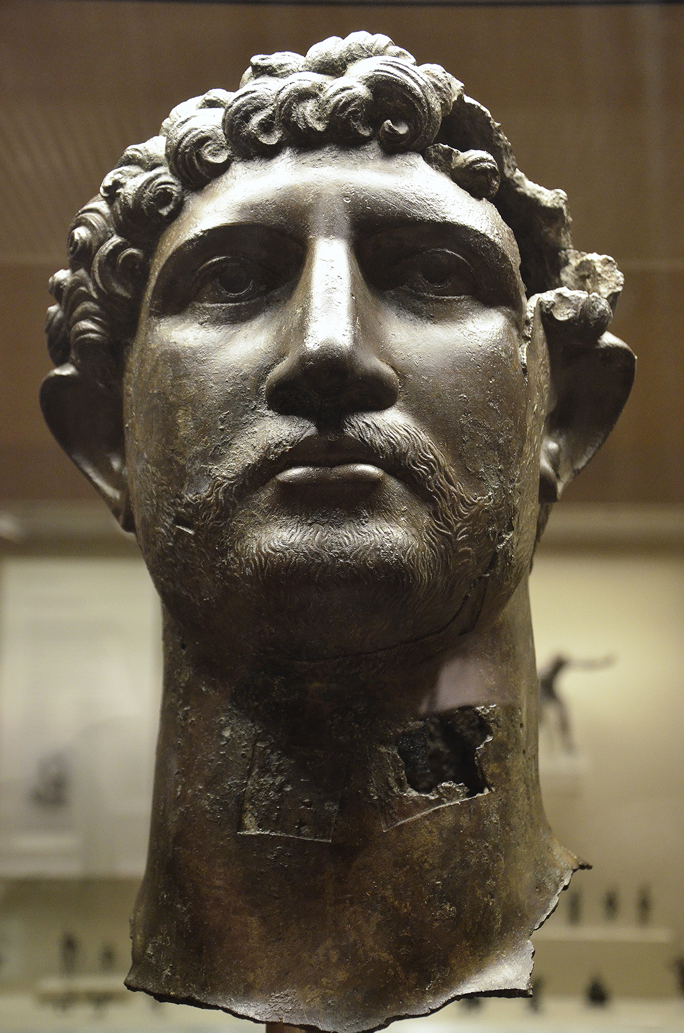
 Since the situation was eventually recovered, only to apparently happen again, we can assume that the Romans must have retained some strategic grip, probably in the East, but they may not have been in a position to intervene to stop either significant casualties in the centre, or with legionary reserve already in the front line, a serious raid on the South. Thus, I see no reason why the burning of London in this period, and even the dumping of Hadrian’s smashed statue in the Thames, could not be a consequence of the “dislocations” in the North. Left: Smashed Bronze head of Hadrian from the River Thames in London [British Museum]
While the losses referred to Fronto could have happened to in the first couple of years of Hadrian’s, these were dealt with successfully [and triumphantly], it seems more likely they refer to the serious legionary losses implied by the effects of the dislocation on the standard and scale of the Wall.
'....... he made for Britain, where he set right many things and - the first to do so - drew a wall along a length of eighty miles to separate barbarians and Romans.'
The military frontier was normally arranged like a traditional order of battle, similar to that used at Mons Graupius, with a light screen of skirmishers, a front line of auxiliaries , cavalry on the wings, and the main legionary force behind this. Similarly, the forward areas of the frontier, the buffer states north of the wall, was lightly garrisoned with small fort on the main routes, the frontier proper was manned mainly by auxiliaries, with cavalry on each flank , and with the main legionary forces concentrated in bases [Chester /York] at rear, giving them the time and space to manoeuvre and counter attack any break through. In deference to the length of the frontier there was also a main cavalry base at Chesters.

A Timber strong point on Trajan's column [enhanced].
Building the Wall was a unique strategic situation, in that the legionaries were the best builders, so were deployed in the front line, split into smaller units, spread across several miles of frontier. While the building of the frontier may have been unexpected for the Northerners, once the business of making it permanent had begun, the intuitive passes to the attacker, by virtue of being able to concentrate forces more effectively at the point or points of attack.There is another glaring obvious problem with the Wall, there is a gate every mile; while it is easy to see the logic behind this, it was clearly a mistake; when the wall was reoccupied most of them were blocked off.

Unusually for the time, Roman forts routinely has four gates, which allowed the defenders the opportunity to counter-attack from any direction in order to trap the attackers against the fortifications, while requiring the latter to consider this eventuality. Translated to the Wall, the gates were not for letting people in, but letting the Romans out to get at the enemy, however, there were usually more solders immediate behind the gates of a fort.
But from the perspective of an attacker, only one gate really needed to be captured and held for a period to get many thousands of mounted troops, probably with carts, chariots and wagons through the wall in good order.
In addition to being stormed, gates can be blocked, so that troops, in particular cavalry, cannot deploy be deployed to counter attack the flanks of the attack.
It is not hard to see that a competently planned attack in force could cause breaches, especially in those areas still under construction, which could leave the Roman forces outflanked, dispersed and surrounded in small garrisons. There is a very important aspect to Legionary losses; during normal campaigning, significant casualties would not be expected from conventional engagements, these tended to occur when forces caught in an ambush or an improperly prepared position.
Where did it all go wrong?

While, it is possible, though unlikely, the temporary defences were weaker here, the principle advantage is that a successful attack here would seize the high ground splitting the Roman forces in two, opening the option to head south on either side of the Pennines.
At the time of the first dislocation, the frontier to the East was mostly completed; this was a more difficult section because of the terrain, and the need to build a complex river crossing across the N Tyne at Chesters. An attack at this point might catch the most skilled legionary spread out in small groups across several dozens of miles. In the aftermath of the dislocation an extra fort was added in this section.
 Since the situation was eventually recovered, only to apparently happen again, we can assume that the Romans must have retained some strategic grip, probably in the East, but they may not have been in a position to intervene to stop either significant casualties in the centre, or with legionary reserve already in the front line, a serious raid on the South. Thus, I see no reason why the burning of London in this period, and even the dumping of Hadrian’s smashed statue in the Thames, could not be a consequence of the “dislocations” in the North. Left: Smashed Bronze head of Hadrian from the River Thames in London [British Museum]
 While the losses referred to Fronto could have happened to in the first couple of years of Hadrian’s, these were dealt with successfully [and triumphantly], it seems more likely they refer to the serious legionary losses implied by the effects of the dislocation on the standard and scale of the Wall.
'....... he made for Britain, where he set right many things and - the first to do so - drew a wall along a length of eighty miles to separate barbarians and Romans.'
Aelius Spartianus The Augustan History, Hadrian 11.1
Being “ the first to” was perhaps about as far as they could go with this achievement; it had been a failure in practice and had since been superseded.
There has always been a problem with Hadrian’s Wall; you would
only attempt build a Wall, a task lasting several years that would involve
dividing your forces into small units spread along 80 mile front, if you had
military supremacy over the region; however, if you had military supremacy,
why build a wall? And why build a continuous boundary taking years that would not be effective until fully completed?
This underlying inconsistency has at times driven
scholarship to a softer view of the Wall, seeing it more in terms of some sort
of imperial monumentalism, a symbolic gesture, a customs barrier, or perhaps even
just a fatigue duty to keep the legions busy.
More recently, the mounting evidence of warfare with subsequent
manpower and skill shortages has given the Wall scholarship a sharper more militaristic
edge, but it has yet to fully dislodge some the older ideas about motivation. The changes of plan and inconsistencies had been rationalised
as series of “decisions” to change the overall scheme, [e.g. a fort decision, a Vallum
decision, etc.], however, the temporary rampart and an understanding of the Vallum
reveals a different initial plan, which was subsequently scaled back or amended as a consequence of the pressure of continued warfare.
Thus, there is no need to assume that they built the continuous barrier piecemeal
over several years, or constructed some wholly unique and symbolic linear monument.
The relationship between the stone wall
and the ditch has no longer to be ascribed to the Wall builders’ unique
ignorance of foundation design, or the need to incorporate obstacles of unprecedented
design and pointlessness. There were no
shortages of timber or stone, and no need to make a Wall out of “turf”, from which, and against all probability, all the soil has subsequently disappeared; there was only a scarcity
of manpower as a result of warfare.

So that is the radical theory; the Roman Army came to the North
and did exactly what you would expect them to do; in response, the northerners continued
to do what they had been doing and would continue to do for many centuries to come.
As visitors approach the magnificent central section of
Hadrian’s Wall, most of the lumps and bumps around them is actually the Vallum,
the wall was crushed to build the road - just as the Wars in the North finally ceased; but it at last realised Hadrian's plan for a proper road to bring troops
from Newcastle to Carlisle, which, in this case, had just fallen victim to the Scottish invasion
of 1745, ironically, a last attempt to restore the political influence of Rome
in England. They nearly got to London.
It is now clear that the Roman Army in Northern Britain was
not on a cultural exchange program, and if, as generally supposed, the prelude
to the building of the frontier was a war involving the Brigantes, [again], then
the Romans would have killed or enslaved everyone they could lay their hands
on; 1000 years later, faced with a similar problem, the Normans just killed everybody.
History has not been kind to the people of the North, or to the archaeology of their enemies, but it is in the vanishing and fragmentary remains of the timber fortifications that the evidence of what really happened here may be found.
- Bidwell, P T, 2005 'The system of obstacles on Hadrian's Wall; their extent, date and purpose', Arbeia J, 8, 53-76.
- Breeze, D.J. 2003. "Warfare in Britain and the Building of Hadrian's Wall." Archaeologia Aeliana
- Burley R 2009, Vindolanda A Roman fort on Hadrians Wall. Amberley ISBN978-1-84868-210-8
- Dunning,. G. C. 1945, Two Fires in Roman London', Ant. J. 25 (1945) 48-77.
- Graafstal, Erik P.: 2012, Hadrian's haste: a priority programme for the Wall. Archaeologia Aeliana, 5th Series, vol 41, 123–84
- Hill, P. R. 2006. The construction of Hadrian's Wall. Tempus32, 13 –16
- Roskams, Steve & Watson, Lez 1981 `The Hadrianic fire of London - a reassessment of the evidence' London Archaeol 4, 1981 62-6 http://archaeologydataservice.ac.uk/archiveDS/archiveDownload?t=arch-4571/dissemination/pdf/vol04/vol04_03/04_03_062_066.pdf
- Simpson F. G. and I. A. Richmond I.A., 1935, The Turf Wall of Hadrian, 1895-1935, The Journal of Roman Studies Vol. 25, (1935), pp. 1-18
- Welfare, H. (2000). "Causeways, at Milecastles Across the Ditch of Hadrian’s Wall". Archaeologia Aeliana. 5 (28): 13–25.
- Welfare, H. 2004. ‘Variation in the form of the ditch, and of its equivalents, on Hadrian’s Wall’. Archaeologia Aeliana, ser 5, 33, 9-24
- Wilmott,T., TheTurfWall https://www.dur.ac.uk/resources/archaeological.services/research_training/hadrianswall_research_framework/project_documents/TurfWall.pdf [Accessed 25/12/2014],
- Hadrian’s Wall Archaeological Research by English Heritage 1976–2000edited by Tony Wilmott http://archaeologydataservice.ac.uk/archiveDS/archiveDownload?t=arch-1416-1/dissemination/pdf/9781848021587_all.pdf [Accessed 25/12/2014],
Bidwell, P T, 2005 'The system of obstacles on Hadrian's Wall; their extent, date and purpose', Arbeia J, 8, 53-76.
Grey literature: Shields Road, Newcastle, Phase 2b, archaeological excavation. TWM archaeology 10/2006
Bidwell, Paul T.; Watson, Moira. 1989 'A Trial Excavation on Hadrian's Wall at Buddle Street, Wallsend'. Archaeologia Aeliana, 5th ser., 17 (1989), 21-28.
Platell, A. C.: Excavations on Hadrian's Wall at Melbourne Street, Newcastle upon Tyne. 5th Series, vol 41, 185–206
http://en.wikipedia.org/wiki/Ancient_Roman_architecture#/media/File:Hadrian%27s_Wall_and_path,_section_near_Crag_Lough.jpgJohnnie Shannon -Hadrian's Wall and path, section near Crag Lough


0 comments:
Post a Comment